Although the settlement known as Weeting probably dates from Saxon times, the land has been used by humans for much longer. The Historic Environment Record (HER) for Weeting includes paleolithic handaxes from before the last ice age and field walking has recovered Mesolithic flint tools. Pollen analysis suggests that this part of East Anglia was covered by deciduous woodland.1
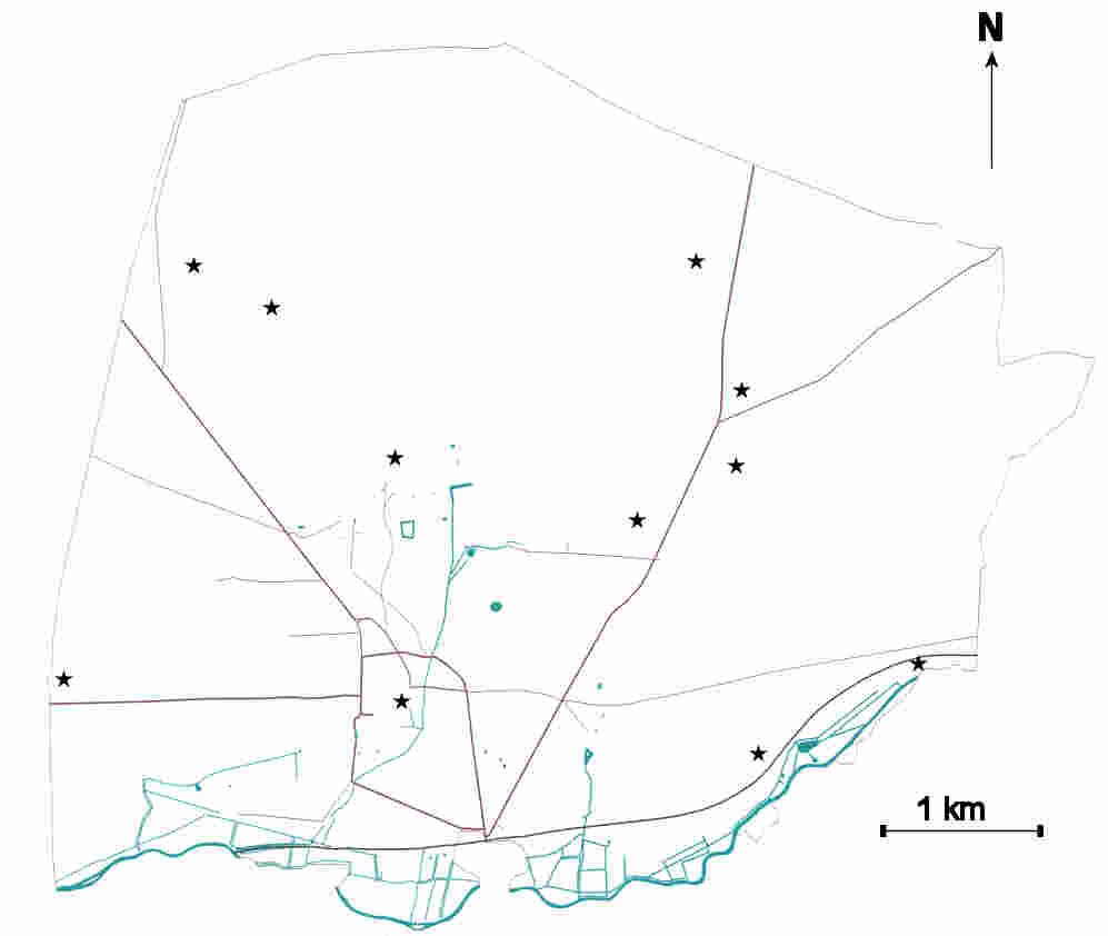
Findspots of Paelolithic artefacts in Weeting Based on data collated from the Norfolk Historic Environment Record
Evidence for occupation during the Neolithic period is widespread throughout the parish. The easily cultivated light soils were able to support a sizeable population. The distribution of findspots is probably a function of the areas investigated by excavation or fieldwalking, rather than of the distribution of artefacts in the soil. By this time a major flint industry had been established. The most striking evidence for this is the area of flint mines towards the eastern boundary of the parish known as Grimes Graves.
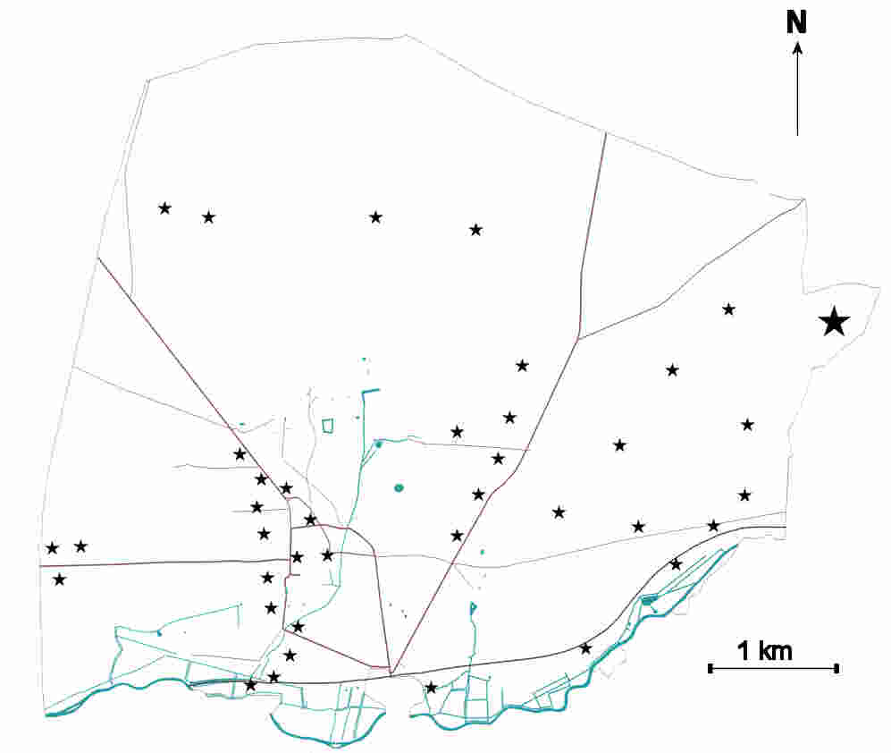
Findspots of Neolithic artefacts in Weeting. Based on data collated from the Norfolk Historic Enviroment Record. The large marker to the east indicates the site of the flint mines known as Grimes Graves.
During the Bronze age Weeting appears to have become a funerary landscape, with around two dozen barrows recorded in the HER. Many of these would have been visible from the Little Ouse and collectively they would, when maintained as fresh, white mounds, have presented an impressive spectacle.
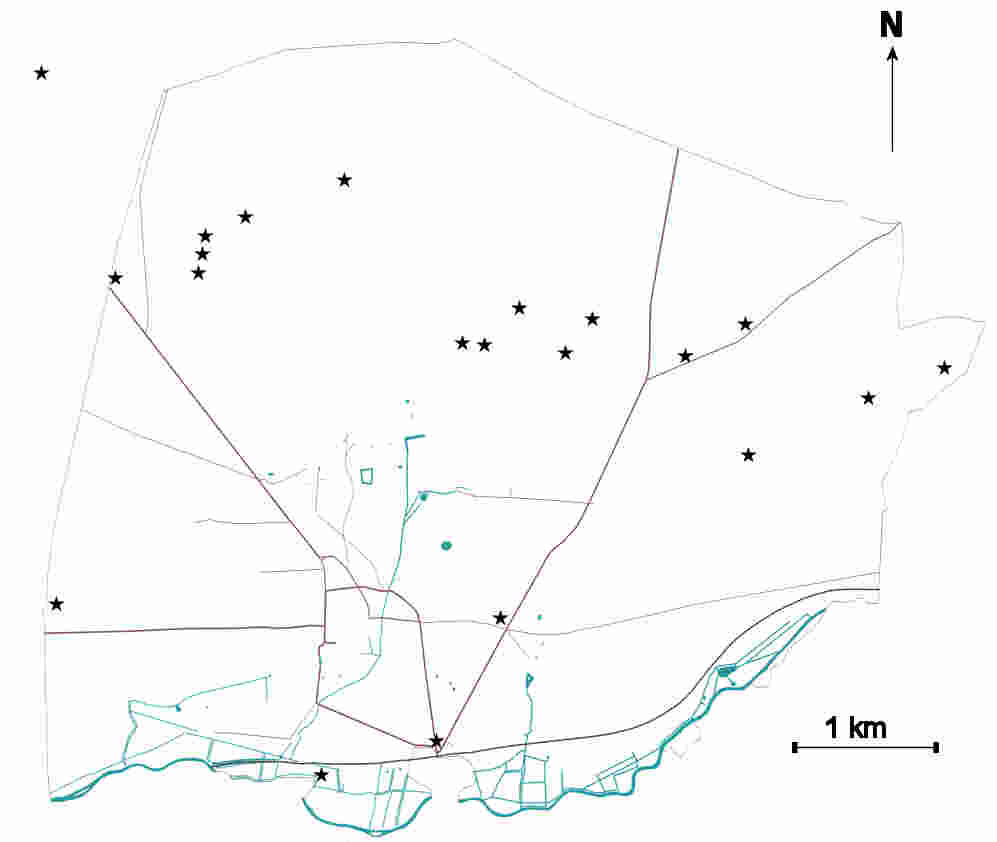
Distribution of known Bronze-age barrows in Weeting
The most prominent barrow “Pepper’s High Hill” lies just off the main road from Brandon to Swaffham.
As is not uncommon, there is little direct evidence for settlement during the Iron Age, but metal detectorists have recovered the occasional coin or broach. Aerial photography has revealed an irregular enclosure to the east of Fengate farm, surrounding a sub-rectangular feature. This latter feature is identified in the SMR as a medieval moat – but the apparent width of the moat, as estimated from the air photograph, is about 2 metres – too narrow to have been an effective moat. Although the features cannot be dated without excavation, it is tempting to see them as representing an iron age stock pen situated within a Neolithic or Bronze Age enclosure.
From the Roman period we have more tangible evidence, with both a villa site and farmyard being the subject of excavations, and material scatters which suggest that there are at least two more Roman settlements in the parish.

Roman finds in Weeting. The stars represent individual finds; the circles represent occupation sites.
Excavation of the villa site which straddles the parish boundary with Hockwold-cum Wilton, showed that during the second century AD water levels rose to the extent that the site was abandoned due to water ingress by 200AD2. The late 3rd century farmyard near modern Fengate Farm is situated on higher ground. The siting of this farm may well be a response to the earlier inundation. The two roman settlement areas to the east of the parish have not, as yet, been securely dated but form a similar pair, with the southern-most on low ground and the more northerly site on a higher, drier location.
Sometime after the fall of the Roman empire, the Saxons constructed a boundary ditch and bank which now forms the western boundary of the parish. Known as the Fossdyke, the ditch extends from the Little Ouse River to the River Wissey and appears to have been intended to partition the headland containing Hockwold-cum-Wilton and Feltwell from the adjoining lands. The bank has been shown to be post-Roman by excavation, as it overlies part of the villa site on the Weeting-Hockwold boundary3.
Another ditch marked the boundary between Norfolk and Suffolk where this swings north of the river. Whilst there is no evidence for the date at which the boundary ditch was first dug, excavation by Suffolk Archaeology found that the fill was no later than medieval.4
Nearer the centre of the village, excavation uncovered evidence for a wooden building, possible a Saxon hall, on the site of the later Norman manor house, Weeting Castle5. Further evidence of the Saxon village has been uncovered by excavation in the 1960’s with pot sherds and some human remains found close to, but outside the boundary of, All Saints churchyard6.
Field walking surveys found sherds of Ipswich-ware and Thetford-ware close to Weeting Castle7. At this time Weeting enters the historical record, as the Liber Eliensis8 records that “Bishop Æthelwold bought three hides at Weeting from Æthelweard for six pounds.” The vill was subsequently left to Æthelthryth the Abbess of Ely, by the widow Ælfwaru.
- Bailey, M. “A Marginal Economy: East Anglian Breckland in the Later Middle Ages.” Cambridge: Cambridge University Press, 1989. p25 ↩︎
- Salway. Journal of Roman Studies 52 (1962): 176-178. ↩︎
- Rainbird Clarke, R. “The Fossditch: a Linear Earthwork in Southwest Norfolk.” Norfolk Archaeology 31.178 (1957): p192 ↩︎
- Craven, J.A. “Land off Fengate Drove, Brandon, BRD 189.” Bury St Edmunds: Suffolk County Council Archaeological Services, 2006 ↩︎
- McGee, C., Perkins, J. “Analytical Archive Report of Weeting Castle.” Department of Archaeology, University of Nottingham, 1985. ↩︎
- Norfolk Historical Environment, ref number 30115 ↩︎
- Norfolk Historical Environment, ref number 37419 ↩︎
- Fairweather, J.(trans). “Liber Eliensis: A History of the Isle of Ely from the Seventh Century to the Twelfth.” Woodbridge: The Boydell Press, 2005. ↩︎